Thank you for your patience as we rebuild our website! 2020-2024

map

GI map of Kunming, APO 627, issued by the U.S. Office of War Information.
A daily map of progress back home by ship after the war of CBI veterans, crossing the Pacific, drawn on ship's bulkhead.
VIPs from both the US and China talk things over during WWII at a base somewhere in China. Senator Henry Wallace gestures over the map, next to Chiang Kai-shek.
American and Chinese military leaders meet to discuss battle in the CBI using a topographical model made of adobe bricks and dirt. During WWII. Notice what appears to be a woman in civilian clothing sitting on a sedan chair on the left. (Images provided via Tony Strotman)
Men from the 21st Photographic Reconnaissance Squadron examine some photographs. In China, during WWII.
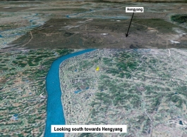
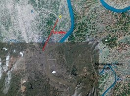
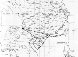
Map showing location of presumed U. S. serviceman's remains north of Hengyang (the yellow thumbtack), in this view looking south towards Hengyang. This is roughly how Donald Lopez would have seen it all on his flight. Here is another view.< Compare this to the map drawn by memory by Donald Lopez, in Hayne's IDPF. (Map image courtesy of Google Earth)
Map showing location of presumed U. S. serviceman's remains 3.8 miles north of Hengyang (at the yellow thumbtack). Note how well this matches the map drawn by memory by Donald Lopez, in Hayne's IDPF. Here is another view. (Map image courtesy of Google Earth)
Individual Deceased Personnel File (IDPF) for Albert L. Haynes, MIA, China.
Zone map for missions by U. S. aircraft on Japanese targets of the coast of China, showing zones labeled 1-4. From the U.S. Government sources.
Sea sweep air mission map for January 1945, showing locations near or in China where attacks were made on Japanese targets by U. S. aircraft. From the U.S. Government sources.